GOVERNMENTAL BODY: WAUPACA COUNTY IMPLEMENTATION STEERING COMMITTEE MEETING
DATE: WEDNESDAY, JUNE 12, 2013
PLACE: ROOM 1068, COURTHOUSE
811 HARDING ST., WAUPACA, WI
TIME: 6:00 P.M.
MEETING MINUTES
OPEN SESSION
1. Call Meeting To Order
Chair Dennis Kussmann called the meeting to order at 6:05 p.m.
2. Roll Call
Implementation Steering Committee Members Present: Kay Ellis (Town of Dayton), Jane Haasch (Town of Dayton), Stefan Shoup (Town of Wyoming), Evan Abrahamson (in place of Michael Orr - Town of Waupaca), DuWayne Federwitz (County Board/Town of Matteson), Steve Frings (Town of Farmington), Marvin Schneider (Town of Caledonia), Art Richardson (Town of Lind), Jackie Beyer (Town of Little Wolf), Terry Murphy (County Board) and Dennis Kussmann (County Board).
Implementation Steering Committee Members Excused: Penny Leder (Town of Bear Creek), Patricia Craig (County Board), Douglas Behnke (Town of Bear Creek), Gary Marx (Town of Scandinavia) and Michael Koles (University of Wisconsin-Extension).
Others Present: John Penney (County Board) and Robert Ellis (County Board).
Staff Present: Ryan Brown, Jean Gliniecki, Jason Snyder and Jeff Henneman.
3. Chair Kussmann read the Open Meeting Statement, “This meeting and all other meetings of this committee are open to the public. Proper notice has been posted and given to the press in accordance with Wisconsin Statutes, so the citizenry may be aware of the time, place and agenda of this meeting.”
4. Approve Agenda As Presented
Terry Murphy motioned to amend the agenda to move “Public Comment” to be prior to the discussion on the proposed amendments. The motion was seconded by Bob Ellis. Motion carried unanimously.
Terry Murphy motioned to approve the amended agenda. The motion was seconded by Bob Ellis. Motion carried unanimously.
5. Approve the Minutes from the May 15, 2013 Implementation Steering Committee Meeting.
Marvin Schneider motioned to approve the minutes as presented. The motion was seconded by Jane Haasch. Motion was carried unanimously. (Note: The meeting that had been scheduled for Tuesday, May 28, 2013 at 6:30 p.m. was cancelled due to not having a quorum.)
6. Public Comment
The following people had comments concerning the proposed sand mine in the Town of Union: Deanna Hannigan, Kelly Hamilton, Carol Peterson, Tania Wadzinski and Bob Ellis.
7. The Committee reviewed the proposed amendments to the Waupaca County Zoning Ordinance.
ZONING ORDINANCE
Amend Table 5 --
“Outdoor Storage or Wholesaling” – should add “C” (Conditional Use Permit) to RI-G and RI-I
The Committee had requested the Planning & Zoning Office to find out about a property in the Town of Dale, Outagamie County as far as what zoning classification was there to allow for the sale of farm vehicles and equipment, trailers, etc. That property had been rezoned to Local Commercial.
“Mini-Warehouse” – should be “P” (Permitted Use) in the RC-N and RC-G
The Committee approved.
Amend 2.12 Premises Conforming as to Use, but Nonconforming as to Structural or Dimensional Standards
1.
Expansion and Restoration: A structure that is nonconforming as
to structural or dimensional standards may not be expanded or enlarged if doing
so would increase dimensional nonconformity. A building or structure is
considered to be demolished or nonexistent if during the course of restoration,
enlargement ofr other improvement, more
than fifty percent (50%) of the pre-existing structure is removed or must be
replaced to maintain structural integrity. If
any structural alteration is necessary for a structure outside of ordinary
maintenance, the structure will be required to be brought into compliance with
current zoning regulations based on the parameters for new construction.
Replacement of a foundation, in part or in whole, shall be considered to be in
excess of the aforementioned fifty percent (50%) a structural alteration. Continuation of the construction or repair shall
be subject to the entire structure being in compliance with current zoning
regulations based on the parameters for new construction and disregarding any
nonconforming status.
a. Expansions to nonconforming accessory structures shall only be allowed if the structure is located further than one-half or more of any required setback and the proposed addition is located entirely beyond the required setback and complies with all additional provisions of this section and ordinance.
The Committee approved.
Sec. 6.05(7)(a) –
Discuss the possibility of allowing an accessory structure to be constructed in advance of the principal building (dwelling) on the same lot, in Sewered Residential, SR, zones with a Conditional Use Permit. OR
Allow an accessory structure to be constructed in advance of the principal building (dwelling) on the same lot, in Sewered Residential, SR, zones to be 5 % of the lot or 1,500 square feet, whichever is greater, as a permitted use. OR
Allow an accessory structure to be constructed in advance of the principal building (dwelling) on the same lot in any zoning district, as a permitted use. The structure shall be sited with relation to appropriate locations for a future dwelling, private well, and on-site waste treatment system, and driveway.
After much discussion, a raise of hands showed that 3 people didn’t want the accessory structure permitted at all and 10 people voted to allow the accessory structure with a Conditional Use Permit as follows:
Sec. 6.05(7)(a) –
7. Accessory Structure: Any detached private garage, carport, or utility shed on a residential lot that primarily accommodates the sheltered parking of a vehicle, the storage of residential maintenance equipment to serve the same lot or a contiguous lot, or a detached shelter such as a gazebo. It also includes swimming pools, greenhouses, wind and solar energy systems for on-site residential use, and private kennels. Attached garages, attached carports, and decks shall be considered part of the principal residential building, not an accessory structure.
a. If proposed to be constructed in advance of the principal building (dwelling) on the same lot, the structure shall be sited with relation to appropriate locations for a future dwelling, private well, and on-site waste treatment system, and driveway. A Conditional Use Permit is required in Sewered Residential zones (SR) with design standards being 5 % of the lot or 750 square feet, whichever is less, and having a maximum height of 25 feet.
Sec. 7.04(5)
5.
Each single dwelling unit or
equivalent principal use that was legally constructed prior to the effective
date of this chapter but does not meet the density requirements of this section
shall be allowed to be rebuilt on the lot within a twelve (12) month period.
If reconstruction of the dwelling unit
or equivalent principal isn’t built has
not started within a twelve (12) month period, then it has to be built
in a compliant location.
The Committee decided to amend the last sentence in this section.
8. The Committee reviewed the proposed amendments to the Waupaca County Subdivision Ordinance.
SUBDIVISION ORDINANCE
Sec. 8.07(3) –
8.07 Lots
3. Access. For access servicing one (1) to four (4) lots, eEvery
lot shall front or abut on a public
road for a distance of at least sixty-six (66) thirty-three (33) feet owned or
by easement, except lots located on a curved street or cul-de-sac which
shall front or abut on a road for a distance of at least thirty (30) feet.
Each lot shall have legal nonexclusive vehicular access to a public street. For access servicing five (5) or more lots would be
defined as a Subdivision as described in Section 2.02(69). Section
8.07.3(a) and (b) shall only apply to land divisions creating three (3) or more
lots.
(a) New lots
shall be located along a public road, except where access is provided via
private road or shared drive. A shared drive
would include an existing access point where more than one (1) property under
different ownership is serviced by easement or right at time of Ordinance
adoption.
(b) Where a private road or shared drive already
exists, lots may be created if:
(1) A road maintenance agreement is established by
the subdivider and approved by the Town. This agreement shall be executed with
the purchase of each lot, noted on the Certified Survey Map or Plat, and shall
address the provisions for the long-term maintenance and snow removal of the road
including the specific tasks, schedule, responsible parties, and funding
mechanism. Any revisions to this agreement shall also be approved by the Town;
(2) The road is constructed to at least minimum
standards set forth in Section 82.50(a) of the Wisconsin State Statutes for
roads serving less than a total of ten (10) existing and new lots or Section
82.50(c) for roads serving a total of ten (10) or more existing and new lots.
The private road improvement would require County review and inspection expedited
through a development agreement between the subdivider and County; and
(3) At the creation of the third lot
principle structure, the road is required to be named and a road sign
erected in accordance with Town standards and E-911 County addressing provisions.
(c) Section 8.07.3(a) shall not apply to new lots
created as part of a cluster/conservation development according to Section 8.0
of the Waupaca County Zoning Ordinance, Chapter 34, provided:
(1) Sections 8.07.3(a) apply, and
(2) The development is limited to a maximum of five
(5) residential lots.
The Committee agreed with the above changes but also to add the word “public” in the first sentence
after “Access”.
Sec. 8.07(5)
5. Maximum Lot Sizes shall only pertain to the
parcel(s) being created by certified survey map and does not
include the remnant parcel. In the event of combining parcels, maximum lot
size shall not apply. Maximum lot sizes are defined through Town
developed overlays which are referenced in Section 87.02 in the Waupaca County
Zoning Ordinance. (The underlined portion has been added.)
The Committee agreed with the added underlined sentence.
Sec. 3.02(4)(c)
(c) Sale or Exchange of parcels of land between owners of adjoining property if additional lots are
not thereby created. A preliminary site plan including distances and acreages must be approved by the
Planning & Zoning Director for such exchanges for the purpose of verifying that additional lots are not
thereby created and that the resultant lots are not
reduced below the minimum sizes or above the
maximum lot
sizes required by these regulations, the County Zoning Ordinance, or other
applicable
laws or ordinances.
The Committee agreed with the strikethrough.
Sec. 8.07(6)
5. 6. Depth of Lots should
be designed with a suitable proportion between width and depth. The lot width
to depth ratio shall be 1:3 (0.33); in other words no lot depth shall be
greater than three (3) times the width, with
the exemption of creating a strip of land for access purposes only. This
access is required to be an outlot and must be stated on the certified survey
map that it is to be used for access only.
The Committee decided to leave this section as is but to add the above sentence as highlighted.
6. 7. Width
of Lots shall conform to the requirements of the Waupaca County Zoning
Ordinance.
7. 8. Corner
Lots shall be designed with extra width to permit adequate building setback
from both streets.
8. 9. The
Shape of Lots shall be approximately rectangular, with the exception of lots
located on a curved street or cul-de-sac.
9. 10.
Lands Lying Between the Meander Line and the water's edge and any
otherwise unplattable lands which lie between a proposed subdivision and the
water's edge shall be included as part of lots, outlots or public dedications
in any plat abutting a lake or stream.
9. The Committee reviewed the proposed amendments to the Waupaca County Shoreland Zoning Ordinance.
SHORELAND ZONING ORDINANCE
We added this section in order to make the Shoreland Zoning Ordinance consistent with the Zoning Ordinance as far as permit expirations. We did change the Zoning Ordinance to 2 years effective February 28, 2013.
Sec. 9.23 Expiration of Permit.
Zoning
permits shall expire twenty-four (24) 12
months from date issued if no substantial work has commenced.
The Committee approved the above change.
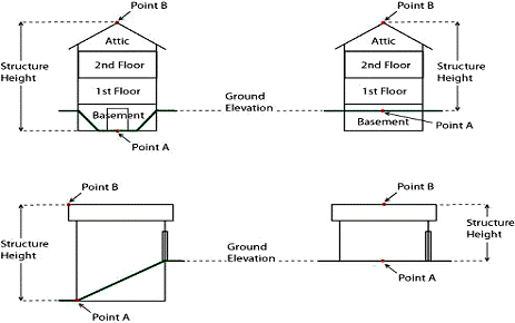
Sec. 4.5 HEIGHT
No structure may exceed thirty-five (35) feet in height. Structure height is the measurement of the vertical line segment starting at the lowest point of any exposed wall and its intersect with the ground (Point A in the following diagram) to a line horizontal to the highest point of a structure (Point B in the following diagram), unless specified under other sections of this code.
Sec. 8.32(2) Shoreline Setback Nonconformities of Principal Structures Between Thirty-five (35) Feet and Required Setback
2) Principal Structure
Between 50 Feet and Required Setback
A
principal structure which is nonconforming as to shoreline setback and which is
located between thirty-five (35)50
feet from the ordinary high water mark and the required setback may be expanded
provided under the following parameters:
a)
No expansion is permitted
within 50 feet of the OHWM;
b)
All expansion is located on
the landward side of the existing structure, wherever practicable;
c)
The overall footprint of
the enclosed nonconforming principal structure (living space) after expansion
does not exceed 1700 square feet;
d)
Impervious surface
standards of Section 6.16 are complied with;
e)
Only one expansion over the
life of the structure is permitted;
f)
Expansion shall not include
a new basement under an existing structure or conversion of a crawlspace to a
basement but a basement may be constructed under a new addition and;
g)
Expansion must comply with
all other ordinance provisions including mitigation requirements.
h)
As an alternative to
expansion under Section 8.32(2)a-g above, an additional story no larger than
the footprint of the original structure and not exceeding 28 feet in height may
be permitted. Height shall be measured from the lowest exposed point of the
structure to the peak of the roof.
a) VERTICAL EXPANSION OF A NONCONFORMING PRINCIPAL STRUCTURE.
An existing principal structure that was lawfully placed when constructed, but that does not comply with the required building setback per Section 7, may be expanded vertically, provided that all of the following requirements are met:
a) The use of the structure has not been discontinued for a period of twelve (12) months or more.
b) The existing principal structure is at least thirty five (35) feet from the ordinary high-water mark.
c) Vertical expansion is limited to the height allowed in section 4.5.
d) The County shall issue a permit that requires a mitigation plan that shall be approved by the County and implemented by the property owner by the date specified in the permit. The mitigation plan shall meet the standards found in section 8.32 (4).
e) All other provisions of the Shoreland Zoning Ordinance shall be met.
b) EXPANSION OF A NONCONFORMING PRINCIPAL STRUCTURE BEYOND THE REQUIRED SETBACK. An existing principal structure that was lawfully placed when constructed, but that does not comply with the required building setback under Section 7, may be expanded horizontally, landward or vertically provided that the expanded area meets the building setback requirements per Section 7 and that all other provisions of the Shoreland Zoning Ordinance are met. A mitigation plan is not required solely for expansion under this paragraph, but may be required per Section 6.16.
c) REPLACEMENT OR RELOCATION OF NONCONFORMING PRINCIPAL STRUCTURE. An existing principal structure that was lawfully placed when constructed, but that does not comply with the required building setback per Section 7, may be replaced or relocated on the property provided all of the following requirements are met:
a) The use of the structure has not been discontinued for a period of twelve (12) months or more.
b) The existing principal structure is at least thirty-five (35) feet from the ordinary high water mark.
c) No portion of the replaced or relocated structure is located any closer to the ordinary high water mark than the closest point of the existing principal structure.
d) The County determines that no other location is available on the property to rebuild a principal structure plus or minus ten (10) percent of the square footage of the original structure that will result in compliance with the shoreland setback requirement per Section 7. The setback reductions in Section 5.4 shall be utilized in determining location availability.
e) The County shall issue a permit that requires a mitigation plan that shall be approved by the County and implemented by the property owner by the date specified in the permit. The mitigation plan shall meet the standards found in section 8.32 (4) , including enforceable obligations of the property owner to establish or maintain measures that the County determines are adequate to offset the impacts of the permitted expansion on water quality, near shore aquatic habitat, upland wildlife habitat and natural scenic beauty. The mitigation measures shall be proportional to the amount and impacts of the replaced or relocated structure being permitted. The obligations of the property owner under the mitigation plan shall be evidenced by an instrument recorded in the office of the County Register of Deeds.
f) The County shall issue a permit that requires that all other structures on the lot or parcel that do not comply with the shoreland setback requirement per Section 7 and are not exempt under Section 5.5 be removed by the date specified in the permit.
g) All other provisions of the Shoreland Zoning Ordinance shall be met inclusive of Section 5.4
The Committee approved the above changes.
10. The Committee reviewed the proposed amendments to the Waupaca County Floodplain Ordinance.
FLOODPLAIN ORDINANCE
1.5 GENERAL PROVISIONS
(a) OFFICIAL MAPS : Based on Waupaca County Flood Insurance Study (FIS), dated (January 20, 2010), volume numbers (55135CV000A) with corresponding profiles.
b) OFFICIAL MAPS: Based on other studies, any maps referenced in this section must be approved by the DNR and be more restrictive than those based on the FIS at the site of the proposed development.
1) Flood Insurance Rate Map (FIRM), panel number 55135C0394D dated December 14, 2010 revised to reflect LOMR.
2) Waupaca County Flood Storage District Map Panels 1-4 dated January 20, 2010 and approved by Wisconsin DNR.
c) Dam failure maps for the following:
1) 100-Year Marion Dam Failure Floodplain Map, dated (March 4, 1993), prepared by SEH Approved by: The DNR
2) 100-Year Iola Dam Failure Floodplain Map, dated (August 1, 2005), prepared by Davy Engineering Approved by: The DNR
3) 100-Year Clintonville Dam Failure Floodplain Map, dated (1997), prepared by Rust Environmental Approved by: The DNR
4) 100-Year Manawa Dam Failure Floodplain Map, dated (2006) prepared by Memo from Bill Approved by: The DNR
(3) ESTABLISHMENT OF FLOODPLAIN ZONING DISTRICTS
(d) The Flood Storage District (FSD) is that area of the floodplain where storage of floodwaters is calculated to reduce the regional flood discharge.
5.5 FLOOD STORAGE DISTRICT
The flood storage district delineates that portion of the floodplain where storage of floodwaters has been taken into account and is relied upon to reduce the regional flood discharge. The district protects the flood storage areas and assures that any development in the storage areas will not decrease the effective flood storage capacity which would cause higher flood elevations.
(1) APPLICABILITY
The provisions of this section apply to all areas within the Flood Storage District (FSD), as shown on the official floodplain zoning maps.
(2) PERMITTED USES
Any use or development which occurs in a flood storage district must meet the applicable requirements in s. 4.3.
(3) STANDARDS FOR DEVELOPMENT IN FLOOD STORAGE DISTRICTS
(a) Development in a flood storage district shall not cause an increase equal or greater than 0.01 of a foot in the height of the regional flood.
(b) No development shall be allowed which removes flood storage volume unless an equal volume of storage as defined by the pre-development ground surface and the regional flood elevation shall be provided in the immediate area of the proposed development to compensate for the volume of storage which is lost, (compensatory storage). Excavation below the groundwater table is not considered to provide an equal volume of storage.
(c) If compensatory storage cannot be provided, the area may not be developed unless the entire area zoned as flood storage district – on this waterway – is rezoned to the floodfringe district. This must include a revision to the floodplain study and map done for the waterway to revert to the higher regional flood discharge calculated without flood plain storage, as per s. 8.1 of this ordinance.
(d) No area may be removed from the flood storage district unless it can be shown that the area has been filled to the flood protection elevation and is contiguous to other lands lying outside of the floodplain.
6.4 FLOOD STORAGE AREAS
No modifications or additions shall be allowed to any nonconforming structure in a flood storage area unless the standards outlined in 5.2(3) are met.
Any violation of the provisions of this ordinance by any person shall be unlawful and shall be referred to the municipal attorney who shall expeditiously prosecute all such violators. A violator shall, upon conviction, forfeit to the municipality a penalty of not less than
$ 25.00 (twenty-five dollars) and not more than $50.00 (fifty dollars), together with a taxable cost of such action. Each day of continued violation shall constitute a separate offense. Every violation of this ordinance is a public nuisance and the creation may be enjoined and the maintenance may be abated by action at suit of the municipality, the state, or any citizen thereof pursuant to s. 87.30, Stats.
The Committee approved the above changes. The Committee also approved the model Floodplain Ordinance from the Department of Natural Resources as sent out to the ISC members.
Jackie Beyer motioned to recommend all of the above changes to go to public hearing before the Planning & Zoning Committee for approval. The motion was seconded by Steve Frings. The motion was carried.
The public hearing for the above proposed amendments is scheduled for Tuesday, July 9, 2013 at 10:30 a.m. at the Waupaca County Courthouse in Room 1068.
The Committee decided to meet again on Wednesday, July 17, 2013 at 6:00 p.m. to continue their review of the Non-Metallic Mining Ordinance.
11. Adjourn
At 8:30 p.m., Marvin Schneider motioned to adjourn the meeting. The motion was seconded by Art Richardson. Motion carried unanimously.